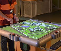
Talking 3D Map Simplifies Wayfinding
A new type of interactive wayfinding map has been developed that can provide audible directions to destinations and information about included buildings when their icons are touched. Researchers at the University at Buffalo’s Center for Inclusive Design and Environmental Access (IDeA Center) partnered with a product developer to create a new wayfinding system to help visually-impaired pedestrians navigate within buildings.
Noting that turn-by-turn GPS directions are virtually useless once a person is inside a building, the researchers looked to solve the problem of “the last mile,” which would give visually-impaired individuals necessary tools to locate their destination independent of outside assistance. In addition to directions, the maps also provide sound effects to create auditory landmarks, such as fountains that produce a sound of water flowing when touched.
Though the technology is specifically designed to help the visually-impaired, the technology also includes a video screen placed below the map to provide illumination to selected icons or locations. This feature provides a multisensory model to aid in locating destinations and a horizontal orientation, allowing users a better spatial understanding of their location, their destination, and what lies between the two.
